Identification and location
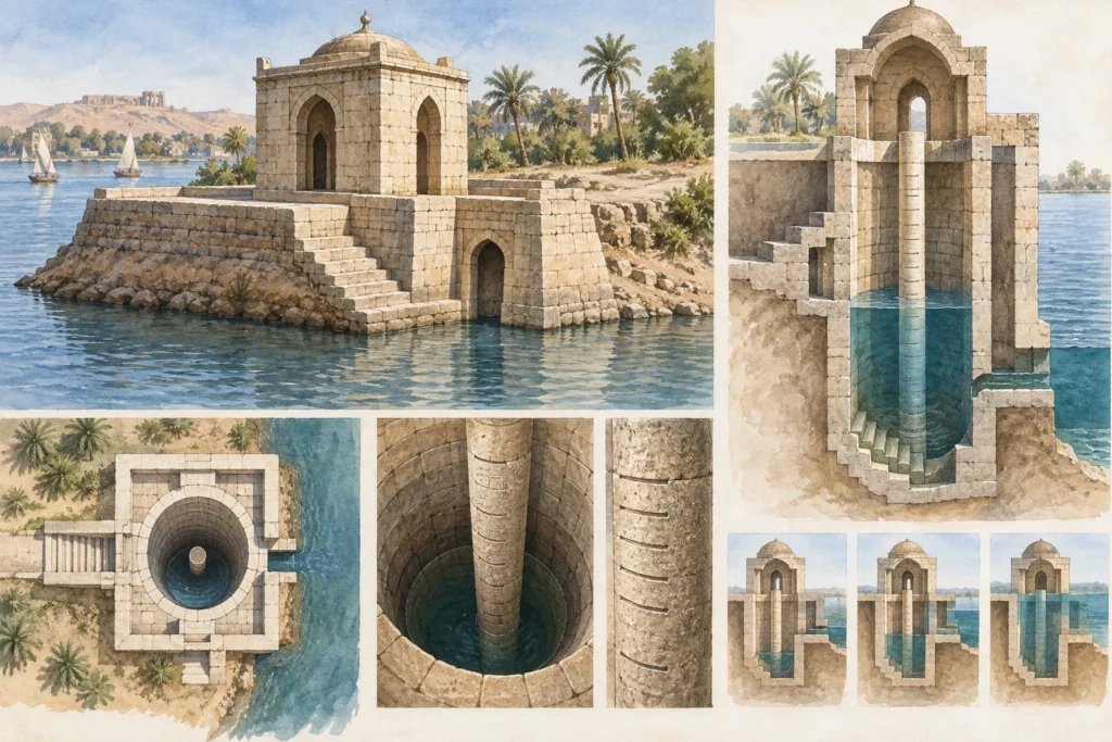
The Nilometer (in Arabic miqyas) occupies the southern end of Roda Island, in Cairo, opposite the district of Fustat (Old Cairo). Its function was to measure the height of the annual Nile flood, in order to prepare dykes and canals and to set the level of the land tax, since the flood governed agricultural production. The Egyptian Ministry of Tourism and Antiquities counts it among the oldest nilometers in Egypt and regards it as the oldest building from after the Arab conquest (AH 20 / AD 640) preserved in its original form. It belongs to the property ‘Historic Cairo’, inscribed on the World Heritage List in 1979.
A Nilometer rebuilt under al-Mutawakkil
The present building dates from AH 247 / AD 861, under the Abbasid caliph al-Mutawakkil. It is not, however, the first on the island: according to Gaston Wiet (1924), a Nilometer was founded there in AH 96 / AD 714, repaired about a century later, then restored twice by al-Mutawakkil; the structure of 247 corresponds to the second of these interventions. Wiet relies on a passage in the biographies of Ibn Khallikan, known only from the Bulaq edition, which gives the account of the builder, Ahmad ibn Muhammad al-Hasib (‘the calculator’), and mentions the first Muslim administrator of the instrument, Abu l-Raddad Abd Allah. The Discover Islamic Art entry also names Ahmad ibn Muhammad al-Hasib as the master builder. His identification with the astronomer al-Farghani, often put forward, has not been established: the Biographical Encyclopedia of Astronomers merely notes that al-Farghani’s name has been associated with the Nilometer of Fustat.
The shaft and the graduated column
The structure is a stone-lined shaft, rectangular in its upper part and circular at its base; the Discover Islamic Art entry describes it in three superimposed levels, a circular base and then two square levels of increasing width. A staircase runs down to the bottom. In the centre stands an octagonal marble column graduated in cubits. The river water arrived through three tunnels that opened into the shaft through three openings on the east side, covered with pointed arches resting on decorated colonnettes. The north and east walls bear Qur’anic verses relating to water, vegetation and prosperity, in Kufic script, regarded as the oldest dated Arabic inscription in Egypt. According to the account reported by Ibn Khallikan, the letters, ‘a finger thick’ (translated from the French), were of lapis lazuli inlaid in the marble, so as to be legible from afar.
Restorations and flood festivals
Ahmad ibn Tulun had the Nilometer restored in AH 259 / AD 873 and had new inscriptions of his own time carved on the south and west walls. Other works followed under the Fatimids, the Mamluks and the Ottomans. From the Middle Ages to the end of the 19th century, the flood was celebrated each year with a seven-day festival attended by the ruler and his senior dignitaries. In 1925, the Mamluk dome that covered the shaft was replaced by the present lead-covered conical roof.
A measurement still to be clarified
The sources disagree on the height of the column: 19 cubits according to the ministry, 16 cubits (10.50 m) according to Discover Islamic Art. The discrepancy raises the question of the cubit used and of the successive reworkings of the graduation. The exact division between Abbasid and Tulunid inscriptions, as well as the author of the structure of 861, also remain to be clarified.
Sources
Sources (consulted on 30 September 2026): Gaston Wiet, ‘Une restauration du Nilomètre de l’île de Rawda sous Mutawakkil (247/861)’, Comptes rendus de l’Académie des inscriptions et belles-lettres, 1924, Persée (in French); Tarek Torky, ‘Nilometer’, Discover Islamic Art, Museum With No Frontiers; Rawda Island Nilometer, Egyptian Ministry of Tourism and Antiquities.