Identification and location
The pyramid of Meidum lies on the edge of the desert, in the governorate of Beni Suef, south of the Memphite region. It belongs to the monumental programme of Sneferu, the first ruler of the 4th Dynasty, conventionally dated to the 27th to 26th century BC depending on the chronology. The ancient name of the place, Djed-Sneferu, means ‘Sneferu endures’. Earlier writers attributed the beginning of the work to Huni, the last king of the 3rd Dynasty; no attestation of his name has, however, been found at Meidum. That of Sneferu is documented on the spot, notably by later graffiti and in the neighbouring tombs. The attested builder should be distinguished from the narrower question of a possible earlier initial project, which has not been demonstrated.
General presentation
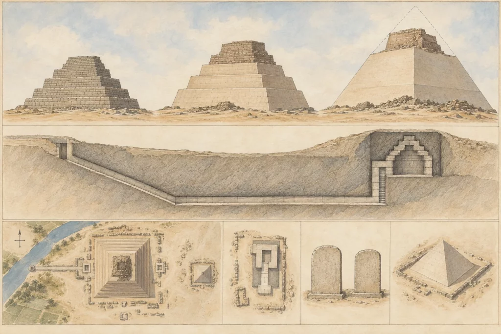
The monument illustrates the transition between the step pyramid and the geometric smooth-sided pyramid. Three main building stages are recognised in the literature and labelled E1, E2 and E3. The core still visible rises from a mass of debris that hid much of the ground-level installations. The present form, sometimes compared to a tower, is neither the original project nor the monument as it stood after its transformation. Sneferu also had two great pyramids built at Dahshur; the relative timetable of these projects and the distribution of the workforce are under discussion. Meidum must be studied as a funerary complex, with ancillary buildings, approaches and a court cemetery.
Monuments and remains
The built mass preserves several steps of the original core. An entrance on the north face, about fifteen metres above the present ground level, opens onto a descending corridor that enters the bedrock. After a horizontal section and two niches, a vertical shaft leads to the burial chamber. Its corbelled roof distributed the loads of the masonry. Relieving devices are also documented above some passages. East of the pyramid survive elements of the funerary temple; two uninscribed stelae marked its space. The small satellite pyramid, the causeway and traces of other buildings make up a wider but unevenly preserved complex. The mastabas of the neighbouring cemetery, in particular those of high-ranking members of the court, set the pyramid in its social environment. The dimensions given for the smooth-sided state are about 144 metres a side at the base and 92 to 95 metres in height: these are reconstructed dimensions for a lost phase, not measurements of the present elevation.
Chronology and building phases
Phase E1 corresponds to a seven-stepped project; E2 enlarged it into an eight-stepped building. Phase E3 filled the recesses of the steps and added a casing to obtain a continuous slope. According to the Egyptian Ministry of Antiquities, this conversion brought the base to about 144 metres. The sequence of these phases is better established than their year-by-year dating. Builders’ marks have fed reconstructions of Sneferu’s timetable, but they do not make it possible to fix the precise pace of the work beyond debate, nor to conclude that another pyramid was begun solely because of an accident at Meidum. The casing and much of the outer mass later disappeared. The old explanation of a single catastrophic collapse during E3 runs up against the stratification of the debris, which indicates deterioration in several episodes. The relative share of technical defects, erosion and stone robbing is still discussed.
History and functions
The project served a funerary purpose and the lasting display of kingship. The inner chamber is laid out with this in mind, even though Sneferu’s burial at Meidum is not established by the discovery of a royal body. The eastern temple and the causeway played a part in the practices linked to the cult of the dead king. The nearby mastabas expressed the relationship between the court and the ruler. The transformation of a stepped silhouette into a smooth form should not be understood as a mere refacing: it changed the overall appearance of the monument and required large quantities of stone. The later buildings at Dahshur show that the choices of slope, casing and chambers remained subjects of experiment during the reign.
Excavations and the history of research
The pyramid was described by travellers before the modern excavations, then surveyed by John Shae Perring in 1837 and by the expedition of Karl Richard Lepsius in 1843. Gaston Maspero opened access to the interior in 1881. William Matthew Flinders Petrie studied the site in 1891, before returning with colleagues, among them Gerald Wainwright, in 1909–1910. Ludwig Borchardt formulated the distinction between the main building phases that is still in use. The surveys of Vito Maragioglio and Celeste Rinaldi clarified the architecture; Ali el-Khouli carried out new research in the 20th century. These studies rest on the reading of the masonry, the debris, the inner chamber and the associated monuments. New Kingdom inscriptions also bear witness to a later memory of Sneferu at Meidum, but they do not themselves describe the phases of the original building work.
State of preservation and research questions
The core survives in elevation, while the outer envelope is largely missing and forms a slope around the building. This situation makes some construction interfaces visible but complicates the reconstruction of the lost casing. Figures for height, angle or volume must always be related to the phase concerned. The question of the collapse has given rise to appealing stories, sometimes linked directly to the Bent Pyramid at Dahshur; the field data do not demonstrate a sudden catastrophe acting as the single cause of changes in royal projects. The attribution to Sneferu is better founded than that to Huni, without fully settling the date of the very first choice of site. The discovery image of this article is a created illustration of the ruined landscape.
Sources
Main sources: Egyptian Ministry of Tourism and Antiquities, ‘The Pyramid of Meidum’, https://egymonuments.gov.eg/monuments/the-pyramid-of-meidum/; UCL Digital Egypt, ‘Meydum, further information’, https://www.ucl.ac.uk/museums-static/digitalegypt/meydum/pyramid/information.html; UCL Digital Egypt, ‘Evolution of Pyramids’, https://www.ucl.ac.uk/museums-static/digitalegypt/pyramids/shape.html; Petrie, The Pyramids and Temples of Gizeh and Medum, 1892, references and plates listed by UCL; Borchardt, study of the building phases, 1928, reference listed by UCL.