Identification and location
Abu Mena occupies a desert edge south-west of Alexandria, beyond Lake Mareotis, between the city and the Wadi Natrun; Peter Grossmann places the site 46 kilometres from Alexandria, the German Archaeological Institute (DAI) about sixty. The World Heritage property covers 182.72 hectares. The place holds the tomb of St Menas, a martyr of Diocletian’s persecution, whose death UNESCO places in 296. The ancient name of the settlement has not survived. Despite its size and a partial rampart, it was not a city in the legal sense: no bishop resided there, and no monastic building has been identified within the town.
From foundation narratives to abandonment
The hagiographical sources go back only to the 7th century. They first describe the miraculous rediscovery of the tomb, a first memorial in the form of a tetrapylon and a church founded under Jovian around 363. Then come the translation of the relics into the crypt under Valens, and a second church, wanted by Arcadius at the request of the patriarch Theophilus and completed under Timothy II Aelurus. Finally, they attribute to Zeno hostels, a garrison and a pilgrim road from Lake Mareotis. Grossmann stresses that these attributions rest on fragile foundations and are not confirmed by archaeology. The pilgrimage centre reached its peak from the 5th to the 7th century. A general fire, probably linked to the Persian invasion of 619, was followed only by makeshift repairs. After the Arab conquest (639–641), the sanctuary passed to the Coptic Church and most of the inhabitants left; the rebuilding of the Martyr Church in the 8th century is mentioned in the life of the patriarch Michael I. The site has been deserted since the 9th century.
An ecclesiastical quarter at the heart of a brick town
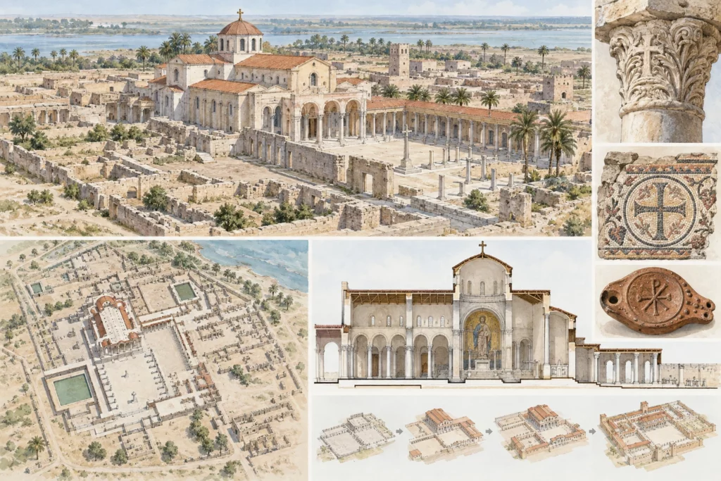
The ecclesiastical quarter, partly enclosed, is organised around a large rectangular pilgrims’ courtyard, with the Martyr Church to the south and the xenodochia (hostels) to the north. A colonnaded processional way, lined with shops, warehouses, two public baths and a large peristyle building, led to it; a covered market occupied the west. The residential districts, outside this sector, consist mainly of mud-brick houses; workshops, cisterns, presses and potters’ kilns complete the facilities. At the end of the 6th century, work began on surrounding the settlement with a towered rampart, a long stretch and two gates of which have been identified to the north and north-west; it was probably never finished.
The Martyr Church: five states over a hypogeum
The Martyr Church stands over an earlier hypogeum. Grossmann distinguishes five phases there. The first is a small mass of rough stones of the late 4th century, probably a cenotaph. A mud-brick building succeeded it at the beginning of the 5th century. Then came a three-aisled basilica, no earlier than the second quarter of the 5th century, with a baptistery and later extended to five aisles. After 528, under Justinian, a tetraconch decorated with mosaics and polychrome marble veneers rose, opening onto the narthex of the Great Basilica. Finally, in the 8th century, a five-aisled basilica with a khurus became the last very large church in Egypt. The Great Basilica, a transept basilica begun towards the end of the 5th century, saw its transept grow from one to three aisles. To the west, the baptistery replaced its square hall with a pool by an octagon roofed with a dome, consolidated in the 8th century.
The North Basilica, the East Church and the hermitages
Outside the enclosed quarter, the North Basilica, three-aisled with a return aisle and a residential atrium, is dated by its pottery to the first half of the 6th century. At 1.6 kilometres, the East Church, a tetraconch even in its outer walls, with a baptistery, probably dates from the middle of the 6th century and succeeded a small basilica; the many two-room cells around it point to a colony of hermits.
From Kaufmann to the rescue from the water table
Excavations began in 1905; Carl Maria Kaufmann published the preliminary reports in Cairo from 1906 to 1908, then Die Menasstadt in 1910. The DAI in Cairo has carried out research on the site since 1961, notably under the leadership of Peter Grossmann. Inscribed on the World Heritage List in 1979 under criterion (iv), Abu Mena was placed on the List of World Heritage in Danger in 2001, the rise of the water table caused by irrigation threatening the structures. After a UNESCO mission in 2018, a solar-powered drainage and pumping system was installed in 2021; the site was removed from the List in Danger in July 2025. The fine chronology of the first developments and the location of the settlement predating the cult remain to be clarified.
Sources
Main sources (consulted on 30 September 2026): Peter Grossmann, ‘Abu Mina’, The Coptic Encyclopedia, Claremont Colleges Digital Library; Abu Mena, UNESCO World Heritage Centre; Das Pilgerzentrum von Abu Mena, German Archaeological Institute (DAI).