Identification and location
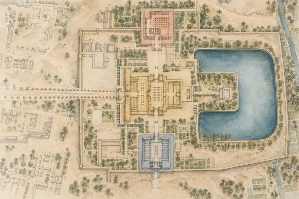
The domain of Mut occupies the south of Karnak, at a distance from the main enclosure of Amun-Ra. A processional avenue linked it to the latter. Its most recognisable landscape feature is the Isheru, a horseshoe-shaped sacred lake that borders the temple of Mut on three sides. This form is not that of an ordinary round basin: it belongs to a type associated with several Eye of Ra goddesses. The present domain brings together buildings and boundaries of different periods. This article therefore deals with an independent cult complex, not a mere annexe of the great temple of Amun.
General presentation
Mut could be represented as a protector of kingship and, in her solar theology, share with Sekhmet a power both beneficent and fearsome. Her role as consort of Amun and mother of Khonsu gains in importance from the reign of Amenhotep III. The lake, the buildings and the approaches may have played a part in the rites without our being able to reconstruct a complete calendar of ceremonies. According to ARCE’s summary of the Brooklyn Museum’s work, the oldest surviving structures go back to Hatshepsut and Thutmose III; the Johns Hopkins research has nevertheless identified evidence of an earlier Middle Kingdom sanctuary. The first visible state should therefore not be confused with the foundation of the cult.
Monuments and remains
The main temple stands inside the curve of the Isheru. The domain also includes temple A to the north-east and a temple of Ramses III south-west of the lake; these buildings did not always belong to the same enclosure. Before the 25th Dynasty, the precinct of Mut comprised mainly the main temple and its lake. Temple A already existed but remained outside this boundary; it received additions from Ramses II, including a forecourt and a pylon. It later changed function over time. The temple of Ramses III was also outside the first domain. Drawing the three monuments inside a wall dated to the 18th Dynasty would thus create a unity that did not yet exist.
Chronology and building phases
The transformation of the precinct is a major fact in the history of the place. Under Taharqa, in the 25th Dynasty, a new western boundary and a gate brought temple A and the area north of the temple of Mut inside the domain. The processional approach was reorganised. The domain reached another extension in the 4th century BC, when a propylon and large enclosure walls were built, also taking in the temple of Ramses III and the southern sector of the Isheru; ARCE attributes this phase to Nectanebo II or to the early Ptolemaic period. This chronology shows that an enclosure wall does not automatically date the buildings it surrounds. Architectural phases, dedications and movements of statues must be examined separately.
History and functions
The statues of Sekhmet are another question of provenance. Many were set up or reused in the area of Mut, but their number and present positions also result from ancient deposits, excavations and restorations. Under Amenhotep III, many statues of the goddess were produced for Theban cult settings; their presence at Karnak does not prove that each one was carved for the spot where it stands today. Temple A calls for the same caution: Ramses II placed there works or blocks from earlier phases. A king’s titulary carved on a statue or a stela helps to follow an intervention, but is not always enough to date the neighbouring building. To explain the function of the lake and the sanctuaries, archaeology, inscriptions and find context must be cross-checked.
Excavations and the history of research
The site was mapped by the French expedition to Egypt and explored in the 19th century. Margaret Benson and Janet Gourlay led the first official excavations in 1895–1897. From 1976, the Brooklyn Museum carried out a systematic exploration of the whole complex, with the aim of understanding the development of the domain and the relationships between its monuments. Johns Hopkins later joined in the study of complementary areas, notably around the Isheru and the temple of Ramses III. The rediscovery of a Thutmosid gate west of the lake and the study of the gate of Taharqa changed the reading of the successive boundaries. Conservation work has also made it possible to clear and stabilise statues that had long been half buried. The date of field photographs must be kept to distinguish a discovery, a resetting and the state presented to visitors.
State of preservation and research questions
The proximity of water, variations in humidity and salts complicate the conservation of the masonry and sculpture. The Isheru remains a reliable topographical landmark on a large scale, but its present shore does not by itself give the outline of each ancient arrangement. Stratigraphic excavation must clarify the succession of shores, walls and floors. The visual composition accompanying this article recalls the horseshoe shape of the lake and the plurality of temples; it is not a survey and cannot assign a precise position to a statue. Any detailed representation intended for publication must rest on the phased plans of the field missions. A caption should indicate whether it shows the state of the 18th or 25th Dynasty or a synthesis of the visible remains.
Sources
Main sources (consulted on 28 September 2026): ARCE and Brooklyn Museum, ‘Mut Temple’, https://arce.org/project/mut-temple/; Egyptian Ministry of Tourism and Antiquities, ‘Karnak’, https://egymonuments.gov.eg/archaeological-sites/karnak/; ARCE, presentation of Betsy Bryan’s research on Mut, https://arce.org/event/arce-georgia-hatshepsut-and-the-temple-of-mut/.