Identification and location
Heit el-Ghurab, transcribed Héit el-Gourab in French, is an archaeological settlement south-east of the Giza plateau, near a great stone wall traditionally called the ‘Wall of the Crow’. It dates from the 4th Dynasty. The best-documented phases relate mainly to the complexes of Chephren and Mycerinus, in the middle of the 3rd millennium BC; lower levels may go back to the reign of Cheops. This point matters: the site cannot simply be presented as the village contemporary with the building of the Great Pyramid alone. The excavations of Ancient Egypt Research Associates, or AERA, concern a group of spaces for work, administration and housing. A neighbouring cemetery belongs to the same social landscape.
General presentation
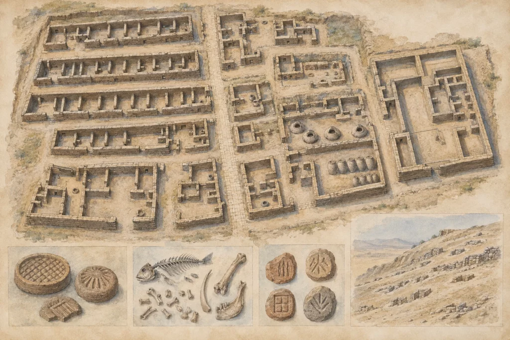
The settlement occupies a strategic position where the pyramid plateau meets the ancient routes towards the valley. Researchers have found a grid of streets and specialised buildings there: long galleries, bakeries, workshops, storerooms, houses and an administrative sector. The faunal, botanical and ceramic remains and the seals make possible a concrete history of supply and of the organisation of labour. The expression ‘city of the builders’ is convenient, but it does not mean that every inhabitant cut blocks or that the complete plan of the site is known. The architecture suggests a diverse population, with temporary teams, officials and production staff. The relationship between this settlement and the building sites must be reconstructed phase by phase.
Monuments and remains
The large parallel galleries have thick walls and long, subdivided rooms. AERA suggests that they may have housed work gangs, perhaps units of about forty men, but this interpretation remains an architectural hypothesis. The streets organise movement between the galleries, the living quarters and the production areas. Ovens, bread moulds and kitchen spaces indicate food production on a large scale. The storerooms and a royal administrative building show functions of control and distribution. The houses are not all identical: some were linked to officials present on the building site. Bones of fish, birds, cattle, sheep, goats and pigs document the supplies, without each species corresponding to a uniform menu for everyone. The seal impressions studied by AERA and Yale shed light on administrative practice. To the west, a cemetery holds modest tombs and more elaborate ones; they are a reminder of the diversity of social status.
Chronology and building phases
The site was occupied and altered over several reigns of the 4th Dynasty. The Egyptian ministry’s overview links the known installations mainly to Chephren and Mycerinus, while pointing to possible older remains from the time of Cheops. The architectural phases, the pottery deposits and the seals make it possible to refine the history of particular sectors, without turning the whole site into a single, simultaneous occupation. Some structures were rebuilt or put to new uses. The relationship with the ancient waterways and the places where materials were delivered is the subject of geoarchaeological investigation. The neighbouring cemeteries bear witness to an occupation that lasted beyond the moment when a given block was set. Research continues and may change the attribution of buildings or the relative chronology of some streets.
History and functions
The settlement served to organise the royal works and to provide for the daily life of the teams. The bakeries and stores show the need for centralised supply; the houses and galleries suggest different forms of accommodation. The seals attest to circuits of administrative control. The food remains tell us about the resources distributed, but they do not prove that everyone received an identical ration or that all the inhabitants did the same work. The skeletons from the cemetery sometimes preserve traces of physical labour and healed fractures; reading them calls for care not to draw general conclusions about the conditions of all the builders. The simplistic opposition between a ‘free town’ and a ‘slave camp’ does not do justice to the variety of the evidence or to the ancient forms of labour mobilisation.
Excavations and the history of research
In the 1980s, Mark Lehner and his colleagues began mapping the Giza plateau to locate the installations that the great building projects required. AERA’s excavations began at Heit el-Ghurab in 1988 and continued in successive seasons. They have documented the architecture, the ovens, the dumps of food waste, the workshops, the seal impressions and the burials. AERA’s field publications and its training programmes with Egyptian archaeologists have refined the division of the site into sectors. The study ‘Sealings and Scribes’, carried out with Yale, deals with thousands of impressions linked to the management of the site. The data are compared with the Wadi al-Jarf papyri and with research on the ancient waterways, but these sources of different origins must not be confused. Research combines stratigraphic excavation, archaeozoology, archaeobotany, ceramic studies and the analysis of administrative archives.
State of preservation and research questions
Most of what is visible consists of foundations and low mudbrick levels, vulnerable to erosion. The excavated limits do not necessarily coincide with the limits of the ancient settlement. The interpretation of the galleries as barracks is plausible but debated; their capacity and use may have varied. The date of the phases under Cheops remains less certain than that of the installations linked to Chephren and Mycerinus. Images of a fully reconstructed town risk hiding these uncertainties. The discovery image for this site is a created illustration of the foundations.
Sources
Main sources: Egyptian Ministry of Tourism and Antiquities, ‘Workers’ Town and Cemetery’, https://egymonuments.gov.eg/monuments/workers-town-and-cemetery/; Ancient Egypt Research Associates, ‘The Lost City of the Pyramid Builders’, https://aeraweb.org/projects/lost-city/; AERA, ‘Sealings and Scribes’, https://aeraweb.org/sealings-and-scribes/; AERA, Settlement and Cemetery at Giza, excavation report, https://aeraweb.org/wp-content/uploads/2022/08/AERA_SettlementCemeteryGiza.pdf; AERA, ‘2015 Area AA-South: Preliminary Results’, https://aeraweb.org/preliminary-report-area-aa-south/.